GIS - Visualization - Multimedia - Web Design - Photography
Technical Animation - Forensic Animation - Spatial Analysis - System Engineering

Looking for my Photography Gallery?
GIS
-ESRI ArcGIS/Spatial Analyst/Viewshed Analysis
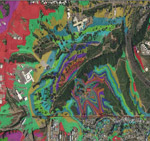
Planned sensor coverage analysis with ESRI based tools. Predictive viewshed
detection coverage of a human target using terrain and LiDAR elevation
models. In this version the viewshed is contoured by color bands indicating
the required sensor declination angle for each point..
GIS -ESRI ArcGIS - Cartography
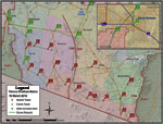
Engineering planning map for potential border security technology and communications (note: planning shown is hypothetical and not implemented or planned). Map content required LiDAR data, field survey, digitizing locally maintained paper maps, and feature extraction of undocumented roads, power lines, and landmarks.

Web Design, Logo, and Dynamic Banner
A corporate internet web site design and secure Linux hosted site. Includes HTML, Flash, and a Macromedia Dreamweaver Template solution which provides design team and administration collaboration advantages.


Web
Design, Flash navigation and dynamic banner
Virginia's Center for Innovative Technology
- Developed
using Macromedia Flash
-
Secondary pages (not shown) are developed with Cold Fusion providing dynamic
information, calendars, conferences, and other colaboration information
for Virginia based high technology businesses.
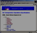
FAA
Air Tranportation Operations Specifications
-
Prototype for overhaul of www.opspecs.com
- Government 508 Directive Accessibility
Design
- Plans for dynamic site design and document
management
- Boeing 747 and header graphic created
using 3ds Max & Photoshop

FEMA
Director of Terrorism Preparedness Prototype*
-
Prototype for hosting at FEMA
- Dreamweaver, Cold Fusion, SQL Server,
IIS
- Government 508 Directive Accessibility
Design
*note: developed in 2000 well before 9/11

- Entry page with navigation completely done in Flash
- A group intranet portal and web capabilities demonstration

- Secure survey with public respondent login
- All Macromedia Flash design, java servlet back end
- Production survey successfully implemented as first Flash based technology proof of concept for U.S. Census in 2000

- Dynamic banner design for DOD contract
- Cross browser compatible and fast load requirements met with 80kb banner


BTG Conference Booth Static Display and Video
Underwater animation developed using 3ds Max and Adobe Photoshop

Wright Brothers 1903 Flyer Animation
In
preparation for the 100 year celebration of manned powered flight a digital
version of the flyer was developed in 3ds Max based on Smithsonian records.
The goal is to provide an educational/historical realistic depiction of
the flights, flight paths, and surrounding Kitty Hawk environment from
the four historic flights on December 17.
Sample Video of Flyer still "under
construction" 5.8mb

BTG Proposal Video Introduction- Joint Chiefs
Recognizable building accurately modeled in 3ds Max. Wireframe and rendered versioned flyouts of this building used for multiple graphics and animation purposes.
note: the building name is now suppressed in this description to avoid search engine results and thwart undesired visitors hunting for this building details I do not have nor wish to share.


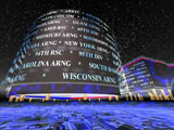
Reserve Component Automation System
U.S Army Reserve and National Guard
Program overview video for Capital Hill Demonstration

Military
Operations Research Society (MORS) Conference '98
Naval Postgraduate School, Monterey, CA
Multimedia
Presentation video
Developed using 3DS Max, Questar World Construction Set, and USGS DEM data for Monterey area

U.S Army Reserve and National Guard

- Architectural Visualization, Boeing Facility, Vienna, VA

Reserve Component Automation System
1999 program overview video - 3 minutes
Conference
Booth Prototype Planning
video

Coin
design and prototype
Reserve
Component Automation System
U.S Army Reserve and National Guard

Logo
Design/Enhancement
Reserve Component Automation System
U.S Army Reserve and National Guard
![]()

GIS - MapInfo - ESRI ArcGIS